Start: Monday, 2 August 2010, 6.30am, Denver (near Indian Creek Trailhead)
Finish: Durango (Junction Creek Trailhead)
I always wanted to do epic mountain biking expedition, far from civilization, on trails among mountains, forest and lakes, exposure to nature absorbing landscapes. It is time to realize dreams; it is time to undertake challenge of conquering wild terrain of Colorado. It is time to find fight and investigate psycho-physical capabilities; it is time to look at nooks of my soul...
Colorado Trail Race (CTR) is a self-supported ‘race’ without fee and without prizes.
Each participant is unaided; there are no pre-arranged accommodations and buffets. Each participant carries along a stuff which in his opinion is worthy and ride the bike he likes. He ought to follow strictly marked route. In sum, rules are formulated in the manner that everyone has equal chances in the race.
Each participant is unaided; there are no pre-arranged accommodations and buffets. Each participant carries along a stuff which in his opinion is worthy and ride the bike he likes. He ought to follow strictly marked route. In sum, rules are formulated in the manner that everyone has equal chances in the race.
The route is mostly singletrack going from Denver to Durango and majority of the route coincide with Colorado Trail. The sum of elevation gain is more than two times ascent of Mount Everest and the distance is approximately 780 km (500 miles). The route is leading through high mountains (2500 - 3500 m) with a peak at 4023 m (13200 feet). One of the toughest sections of the length about 300 km (200 miles) is leading completely out of civilization which means that there is no possibility of resupply (no shops or gas stations).

In 2009, 40 daredevils started and only half of them finished the ‘race’. Considering the character of the event as well as the pace the word "race" is in quotation marks. I planned to go back from Durango to Denver on my bike. How was it? It was as usual in my case ;-) intensive and extreme ocasionally.

I will try to render the climate of the expedition in this blog...
Acclimatization

After peripeteia related to the worst flight in my life it should be only better. (Thunderstorm over Washington DC caused that my flight to Denver was cancelled; I spent many hours on the airport, my suitcase with a bicycle did not arrive, there were only wheels which I packed inside a cardboard and zippered bag. I arrived to Denver in the middle of the night and I did not have any transportation to my hotel so I waited on the airport until morning).

I reached Best Western Inn hotel in Castle Rock taking the earliest available Super Shuttle service (ach what a superb engine whir!). Fortunately I booked three nights before CTR for acclimatization so the suitcase with the bicycle and equipment arrived on time.
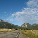
Castle Rock city is located dozen of kilometres southerly from Denver and about 30 km from the CTR start. In fact the hotel is placed on the suburbs of the city but there was a city market and Walgreens close to the hotel so it was no problem with the food. Moreover in the hotel they served decent continental breakfast. The bed inside the room was huge (king size bed) and besides me it would hold three girls more :)

Local infrastructure and space make staggering impression. In principle it should be driven by a car everywhere. I suppose that I have been looking strange walking on roadsides and crossing multi-lane roads.


The name ‘Castle Rock’ comes from the rock which dominates above the city. Rock Park has been founded around this rock with some trails.

I was walking a little next day or even more than a little because I walked more than 20 km. I saw Meadow Estates, typical American style, sleek, just like in movies. Mountains could be seen from there; the first row of mountains looks – in category of a pile – like Beskidy Mountain Range in Poland whereas distant summits are much more higher and even covered by snow.


Here in a valley (2000 m above sea level) the sun is starting operate harder at about 1 pm and it becomes blazing heat and each snip of shade is saving.
Day 0

The road ride with full load to the starting point of CTR took me 20 minutes more than without load. Also lower gears were used. I found camping near Indian Creek Trailhead; there was one participant (Sean from California). I saw similar bags, carbon Cannondale 29er with lefty... it looks like very light equipment. We chatted a little bit, and then I rode to check the beginning of the trail. There was a light downhill, narrow trail, a few stones, roots, some switchbacks, creek, green forest around and meadow. Just like in Beskidy Mountain in Poland – I thought. I like it! After crossing a creek I made a turnover because the sky begun to rebel. I went to the Rampart Food Market for Chamburger (Food Market in the middle of forest!) and then fast back to the camping place. When I pitched a tent it started raining.
Next the rain stopped and few guys joined, one of which (Nathaniel) treat me a beer. If I am correct it turned out next, only one of them finished CTR.
Start
 |
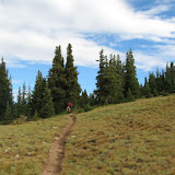
| CTR - day 1 photo gallery |
CTR began on a small, gravel parking lot surrounded by forests. I was much more before the start time but the parking was full of vans and cars, around which participants prepared themselves and unique equipment (I saw full range of bikes starting from full suspension bikes through hardtails, singlespeeds to 29ers). I found Stefan – organizer, which explained me how to use SPOT GPS tracker. Participants gathered together quite long and the event started with 15 minutes slip at 6:45. The start was preceded by short speech given by Stefan who mentioned that the weather forecast is not conducive for us for the next couple of days and we should be prepared for thunderstorms.
About 40 participants started moving slowly down in the direction of Indian Creek. At the first technical jump on a narrow path a small traffic jam was created. One moment further I saw someone who crushed on the soil not dangerously. At the beginning the route leads through forest with soppy terrain. It got steep and it was necessary to push a bike. After some time of hilltop and traverse riding, downhill began with massive amount of switchbacks (revelation!).
After crossing the Platte River the terrain and ground changed completely – it becomes dry and sandy-gravelly. The trail guides cleverly by bends, not very steep, so most of the time it is possible to manage uphill even with load. I have tried ride quite fast through this section – a little desert uncovered on a ridge – before the sun reached zenith and made horribly hot. The landscape was totally different in comparison with those in Poland. Unfortunatelly, the section finished and one must made a detour using gravel and paved roads around wilderness area, where bikes are prohibited.
I found pleasent restaurant in Bailey. I have eaten cheese soup but I was not able to eat pasta with meat because main course was huge. I also stop off gas station for resupply and set off. It was quite a lot of time to twilight to cover a highway leading to Kenosha Pass. At the beginning the higway was without a shoulder until additional lane for slow vehicles appeared on uphill.
It started raining, Dylan cought me up and he descried a shelter, where we avoided getting drenched luckily. It was not too long because on the pass the rain reappeared. When it made clearer we decided to continue the ride through the path strew with wet roots. Unfortunatelly, the storm hit, lightnings struck merciless when we rode through meadow. The path transformed into a creek. We decided to find a place for a camp in first bushy trees. Pitching a tent in the rain and in too soft soil was not very fortunate because due to bad pitched tent my sleeping bag soaked a little (I was worried about it because I had down sleeping bag). Fortunatelly, I had dry clothes. It was cold and I don’t know if I slept at all.
Altitude gain records
 |
| CTR - day 2 photo gallery |
We were greeted by cool but sunny morning. During packing we heard that some biker approaches. We started out together practically up to Georgia Pass. We, with Dylan, were happy that we didn’t ride this section during the night because it would be the shame to miss such incredible views spreading from grassy space. Open space and altitude caused that I breathe heavily.
Downhill from Georgia Pass on wet roots and rocks delivered incredible impressions. From time to time it was so difficult that I stopped and walked down with my bike few meters. I rode down little faster than Dylan who caught me in a valley when I was after a break for power bar and I was refilling water from the creek which I disinfected by Katadyn pills. Dylan filtered water while I starded out.
As a matter of fact after the first day I was worried about break pads because in a rain and with such an amount of downhills they could wear out fast. I decided to break less; anyway it looked like that it is possible to gain average speed only on downhills and slightly descending traverses.
Riding next uphill I overtook one guy pushing bike easy who – to be honest – was a little overweight. I was wondering how it was possible that he made the way. He didn’t sleep at all, he rode all the night! Impressive!
The same day further the route was plenty of traverses and easier downhills but only to Swan River. Next it was technical uphill. I heard comments from passed by tourists: ‘amazing’. Soon, uphill was too steep and unrideable up to the moment when the trail lead through valley overgrown by grass and flowers. Here, I saw in front of me rising peaks and I thought: ‘Holly shit! How I will get there’. It was the first nasty section where it was tough to push the bike. It took me long to climb on Tenmile Range. It was one from many sections, which seemed that it will take about two hours but in reality it took five. Behind me stretched the view on Dillon Lake near Frisco, whereas on the other side of hogback, through the sky covered by dark clouds, glittered a thread of highway in deeply indented valey. Downhill to the valey was very steep and momentarily dangerous due to slippery stones.
I spent quite a lot of time in Copper Mountain Resort. I stockpiled on gas station where I met James. James bought food in a flash and raced further. I felt like to eat something warm. I have eaten cheese soup in Endo’s Grill & Bar. I was not able to eat their speciality – nachos – because it was too spicy. I moved to fight with the next pass. I saw James on a gravel road who rode in opposite direction. He had broken spoke in the front wheel and decided to ride to Frisco for repair. It comes from his story that it was the second failure of his wheel. I was not surprised seeing his butted up to 1.5 mm spokes.
After turning from gravel road, a path made slushy, waved by roots. The path was rising in valley up to the pass. I was more and more tired but I wanted very much to realize my plan of doing 100 km (62 miles) per day. I rode unusually slowly and some sections I walked. Darkness cames fast and I walked to Searle Pass pushing bike with a lamp on. Some tourist-freak walked down with lighting. Undoubtedly, I missed some views, because I saw only on the light of my lamp flowers among the meadows of the valley in which a creek meandered. From Elk Ridge (3743 m.n.p.m – 12280 ft) was decent downhill, additionally difficult because of riding with the lamp. The end of downhill was vile on loose stones, worser than in our Beskidy Mountains. When I was enough low I found pretty nice place for pitching a tent among grass on the edge of birch forest. In the middle of the nighi I lay down on a mat and fallen asleep.
In that day I conquered more than 3500 m (11500 ft) of uphills.
Lazy day
 |
| CTR - day 3 photo gallery |
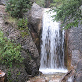
After I looked out of the tent I was surprised nicely because I saw nearby Dylan who pitched a tent just lower between birches. We shared impressions of the last riding day and then Dylan continued his ride. I was hoping that the sun will show up; I packed my stuff and then it started raining. I waited under a tree, washed my shorts in a creek near waterfall and finally rode last metres to a valley.
My legs did not want to cooperate with me but luckily up to Leadville the terrain was flat. The sun appeared and on the way it was necessary to change clothes and repack stuff. It was standard activity. Mornings were cool (the temperatures droped even to 0C degree) and after some time I warmed up. The sun at about 9:30 caused that in morning clothes was too hot. Fortunatelly, the air was dry and I sweat not much even on back under backpack.
I have eaten pizza in Leadville and met Dylan who had a problem with a wheel and waited for repair. Leaving the city I saw in front of me the sky covered by black clouds. It made up that the route lead in that direction and next turned. I hoped that I would escape the storm and sidle. The rain caught me just only for few minutes. As Stefan pointed out, there is a saying: if you do not like the weather in Colorado, wait 20 minutes.The weathear in Colorado changes faster than the woman’s mood, indeed ;-)
It was a lazy day. Fortunatelly the route was unusually easy in comparison to previous two days, after which – to be honest – I was woeful a little because I was given hard time. I did not know what to expect farther. I knew only the route profile and some characteristics which I found in trip reports published in the internet. I knew that the worst section is before me and I did not want to ride like a crazy.
This day was full of fast traverses and light downhills among birch forests. Next panorama of Twin Lakes had arisen. The view was beautiful, the sun was shining and it was tempting to go for a bath. Buena Vista was far away regrettably – I wanted to reach the town before 10pm. After by-paasing a lake along the coast on fast gravel path the uphill beguns. On the summit it started raining heavily and practically last 20 km I rode in downpour. I tried to wait until it stops raining in one of short tunnel forged in rocks but this time saying about the weather in Colorado did not want to fulfill.
I reached Buena Vista cold and little soaked. I found a motel and took a dream shower. It turned out that the notes about grocery opening hours prepared by Stefan were inactual. All groceries and restaurants were closed at 9pm. It remained motel’s coffe and Cliff bars (I had enough of these bars, these bars were sickening). I washed my clothes and went to the bed. Next day in Mount Princeton Hot Springs it supposed to be the beginning of 300 km (200 miles) section whithout any possibility of resupply on the way. Hence, I decided that I will start out riding early morning in order to be in Mount Princeton Hot Springs as fast as possible for resupply, thus not waitng for grocery opening up to 8am in the morning in Buena Vista.
Clear mind
 |
| CTR - day 4 photo gallery |
Bike riding is beautiful because human is focused on actual situation on a route, balances with his body for optimal line, steers clear of obstacles, operate with brake levers... Intensive exertion causes increase in external stimulus sensitivity: fragrances, tastes, colors, humidity... You probably know that feeling of freedom, independence and power able to subdue the space. The mind stays clear, troubles evaporate to overspace, and you do not think about taks to do in work... You just pedal.
I arrived to Mount Princeton Hot Springs and resupply in small but well equipped general store; unfortunately very expensive. James once again overtook me. I decided to eat big dinner in a restaurant.
Next was a climb on sandy-stony path. As altitude increased, views became more and more impressive. White rocks with steep slopes, in lower parts overgrown by coniferous trees, on the background of blue sky and cumuluses looked majestatically. Further it was possible to ride, slowly - to be true – because it was not steep but technically demanding. In the meantime was drizzle.
Before downhill to Hwy 50 I was hooked by friendly lady - mountain biking passionate. We chatted for about 15 minutes about the race and life. He asked if I need something, she wanted to help somehow very much. Nevertheless, I was very well stocked.
Uphill up to Marshall Pass promised to be easy – smooth gravel road. But the trail turned left and leaeded along a creek, next it became more and more steep. In the meantime chicken salat made me feel ill. Analysing altitude profile I hoped to got to the pass and pitch a tent slightly lower. I pushed the bike slowly during the night up to summit but I was so weak that I was not able to make to Marshall Pass. I decided to stop few miles before the pass. It was fair; I inflated my mat, dressed all my clothes and jumped into a sleeping bag. After some time I spewed. I felt better. Probably I have fallen asleep for a while. An alarm clock was set at sun rise.
Pain
 |
| CTR - day 5 photo gallery |
Sargents-Mesa section is biker’s Mekka, mentioned with a tone of caution in every report found in the internet. Modest looking altitude profile is hiding trails full of loose stones escaping from under wheels and precluding the ride effectively. The ridge trail of the type up-down, up-down is simply deadly, especially in full sun.
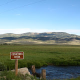
Mountains look marvellous at sunrise. I am so tiny on their background and so weak as well. I do not have willingness to eat, I have stomach ache but I know that it will be good. Maybe that was good that I did not ride at night because downhill from Marshall Pass was from time to time Beskidy-like downhill (read this: it was tough and few metres I even gave up). Few moments later it turned out that somewhere during rumble on stones my camera fallen out. Fortunatelly the camera have been found by one of three bikers which caugh me. We made joint breakfast. After a while, still together, we got water out of a creek but farther I was not able to hold their pace. I filled weter bladder and nalgene bottle to full but under a heat and open space the water was consumed very fast. After having ride through vast pasture I rode through sparse forest. Most of the time the trail was leading through ridges and practically on each peak I pushed my bike. I did not make any breaks. I had run out of water. I rode almost on the power of will, cauting miles to Lujan Creek. I dreamed about reaching the creek, drinking water and resting. On last metres on a forest exit before the creek I saw ‘Trail Angel’. The Colorado Trail Foundaition, on occasion of the race, organizes free beverages and sweets for participants. Three bikers whose I have met before just pulled out of the ‘Trail Angel’s’ tent congratulating me for my persistence. I took a seat under the tent, drunken cold coca cola, chatted with the ‘Trail Angel’ and I have eaten a few cookies.
Next I missed a turn from road to consecutive trail section. I had to go back few hundred metres. I drove in grassy, humid valley, very much contrasting with previous section where the ground was burned by the sun. I was too tired for attacking Cotchetopa Hills. Approaching clouds were also not very encouraging for subsequent ride. I pitched a tent on the edge of forest exceptionally early. I wanted to recover.
Cotchetopa Hills
 |
| CTR - day 6 photo gallery |
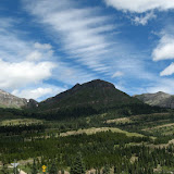
On the morning the grass was covered by frost. It was clear; Cotchetopa Hills arising from remoteness in a sun light which freshly came up, made on me terrific impression. In general I was on spacious savanna’s plain, where colourfull rocky formations banked up on a blue sky background and a mountain summits in a distance. The vastness of space was striking. It was one of such moments that I didn’t mind to race (despite of in favour of gravel road), I only wanted to contemplate the landscape. I was glad that I could admire such a different from our, polish, landscape.
Gravel road slightlhy ascending to Los Pinos Pass was piece of cake but climbing took quite a lot of time. I was craving for milk, I thought about milking cows which pastured around...
After reaching Hwy 149 I had to mind: side-track about 16 km (10 miles) to Lake City for resupply, loosing 800 m (2600 feet) of altitude or attack the highest point on the route (Coney Summit) with 4 power bars and rest of jerky. It was midday and it seemed that I would be able to get up to the summit before darkness without any problem. Contours looked not bad thus I decided to attack the summit.
The summit of loneliness

On the road I lost about 300 m (984 feet) of altitude only to climb on the next pass – Spring Creek Pass. There I rode again on the path which leads me to alpine-like meadows. Forest-less vastness of space exhibited endless grass and mountain ranges. Sharp rocks densely lied down stick out from grass and riding uphill was practically impossible. Sometimes the trail was ‘untrampled’ completely and I went by cairns marking trail. In certain moment double track showed up following through desolated meadows, which seemed that had no end. The vastness of space paralyse sometimes. The path went down slightly and shortly leads to successive hills. It was beautiful and at any minute I stopped in order to take pictures … for you dear reader.

I have been conquering successive ascents and I kept on the lookout for Coney Summit (4064 m – 13333 feet, the highest point on the route). It took me very long to get there. When it seemed that the mountain in front of me is a proper summit, behind the summit showed up next and next… During CTR it seemed that given section would take 2 hours but in reality it took 5 hours!
The altitude got in my hair. At altitude of 4000 m (13123 feet) allowed only about 65% of oxygene in relation to sea level; I actually live exactly near the sea. Legs become somehow oddly soft, the head felt like a drunk. All that transferred into slower ride. And reaction was slower which in sum fruited in falling over the bar. During whole CTR I had in sum three minor falls. Two of them were classic over the bar caused by too slow speed, which in turn caused that front wheel was not able to roll over the obstacle. Other time the cause was overspeed on the path leading through deep narrow rut. This time I failed to keep track and fallen out of rut; knowing that I was not able to control the bike, I fold up to fall. It went without scratches but next hour I rode down more constantly ;-) It was really good score because on the route were demanding sections, there were many places where was possible to crush and maul myself as well as the bicycle. I must admit that technical skills learnt in Beskidy Mountains and Alps payed during CTR.
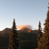
Because of slow ride I began to worry that I would not approach Coney Summit before the darkness. In addition on next slope leads very steep climb like in high Tatras. It was high rocky shelfs and it was difficult to carry the bike to the summit. The sun went down when I climbed switchbacks leading to Coney Summit. It started raining. In distance a thunderstorm blown up. In distance summits time after time were lighted by lightning. It is the most dangerous miracle of nature which can meet a tourist on the Colorado Trail. As a matter of fact statistics reveal that one person hit by lightning died in Colorado in 2009 but there were much more injured. On the extent of years this looks much worse… (Colorado Lightning Resource Page).
I run away from thunderstorm riding down fast to Carson Saddle (3770 m – 12399 feet). I was very tired and dreamed only about lying down. But I run out of food and had to continue night ride or in point of fact wander in the rain. The trail climbed again up to 4000 m (13123 feet). Next a scenario of the type up-down, up-down repeated, struggled most of the time with the bike next to me. I was in a bad condition; I was faint and repeated to myself: ‘don’t stop’, ‘you’ll manage’, ‘keep on rolling’. When I saw successive steep climb I wondered ‘how far one might climb’ and checked an altitude graph in my gps.
Most of the Colorado Trail I rode alone. But on this section the loneliness reached the top, isolating from feelings of fear, uncertainty, cold, starvation and tiredness. I was certain that none of participants summoned up to ride at night in this terrain and that the next biker is far behind me. Looking at blinking diods on Spot localizator I realized that rescue action in this area must be very hard. ‘Alone, in complete desolation, in foreign country, family home is far away…’ – I thought. ‘Maybe now someone follows a dot, on screen of a monitor, symbolizing my position?’ And again I repeated to myself: ‘don’t stop’, ‘you’ll manage’. I should add – ‘do not think about loneliness’, but this is enemy who attacks out of the blue (‘the loneliness is a dog which bites unawares’ – sings Lady Pank in their song).
The night fight with mountains or rather with my weaknesses, ended with my victory in the morning when I reached Silverton.
Award
When I arrived to Silverton early morning, the city slept and everything was closed. Only laundry was opened, in which I grabbed dispenser with chips. I understand how the laundry is organized, washed and dried my clothes. I have eaten huge Burito in Bent Elbow restaurant which was opened first; I bought food, drunken enormous amount of orange juice. I was full to the extent that I was not able to ride. I made a break before uphill on highway to Molas Pass.
On the pass I was again on the trail and soon I saw beautiful lake composed into mountains. With a view of hardest section conquered in extreme conditions at night, I ascertained that I deserve for a little rest. I took a short nap at the lake. At the time I knew that I would be able to finish CTR, enen in less than planned eight days. Moreover trails and views were such brilliant that I decided to divide the last part of the route leading to Durango into two days.
This day was an award for the rigour of previous day and night. In my opinion the segment from Molas Pass practically up to Durango (maybe except section about few miles long) is the best - in relation to mountain biking – segment of Colorado Trail. Many technical but rideable sections, both uphills and downhills ensure great fun. For this reason, inter alia, I decided not to be in a hurry. There could be found each type of surface: stones, roots, loose stones, clay with stones, harpacked sand with gravel, mellow uphills guided through switchbacks, technical traverses, fast downhills, creek crossings and that is all in a marvelous scenery.
The ride was good, my body adapted to load; I enjoyed technical path, made lots of breaks for photos and snacks. It can be said that I had bananas on my face practically all day :-). I thought about my friends, bikers. I was certain that the trail would be to their liking. It was a pitty that they were not with me.
This segment looked again different: shining in the sun summits in colors from rusty through grey-brown up to white; down wanton vegetation, light green leafs up to waist, flowers and bush in various tones of green on soppy meadows along creeks, somewhere conifers tied to even vertical rocks… Such views were – inter alia – in a magnificent canyon. In the canyon’s valley flew creek and the rainbow was spreading on the wihte background of mountain summit. Something from this description is visible on photos.
Almost in each place on CT you can pitch a tent (of course if you find flat piece of ground) in a condition that you will comply general rules on the trail – leave no trace. Merely in some places like tourist attractions (mostly accessible by a car) bivying is allowed only in designated places or camps (a fee is required). Sometimes, on the side of CT, it was possible to find very nice place for bivying or campfire with circle of stones and flat spot. This time I prepared nice place by myself. During CTR I had no time for making campfire and cooking. I also did not take a gear in order to minimize a weight for carrying stuff. I went to a ‘bed’ earlier than usually.
Countdown

It came last day of ‘the race’, which actually was a continuation of beautiful route from the previous day. I climbed following the trail to higher side of mountains. The ridge trail was much faster than the section through canyon. Everytime one could admire brilliant mountain panorama, summits immersed in clouds, incredible rocky formations and ponds among green meadows.
The time run fast. The trail near Kennebec Bench became unrideable, guiding at the edge of – otherwise attractive – cliff. The altitude about 3700 m (12139 feet) and open space caused that again it was difficult to breathe. The result of altitude was swelling most of all my hands but even the face. My hands become numb up to degree that it was difficult to hold a pencil…
I began to countdown miles and elevations to finish. At the summit I was run out of water and food. It remained about 60 km (37 miles) to the city- most of the time downhill, supposedly, but not exactly. After the longest downhill on the route which delivered incredible emotions (it was simply the fight for survival momentarily) succeded heavy traversing and climbing. I had not any will for any uphills and I thought only about eating. That day I overdo with the strategy of climbing with minimal volume of water in bladder on my back. I felt that I was dehydrated. I had no will for any unnecessary break. I even did not oil the dry and creaking chain. In the last part the trail followed slightly descending valley. There was quite a lot of technical stuff so it was necessary to be focused on the trail up to the end.
In the valley was horrible heat. The route ended at junction creek. Nobody was there; no interview, no handshake but that is the specificity of event. I write down: the time 7 days 13h, the distance 784 km (487 miles) and 19360 m (63517 feet) of total elevation gain. I felt very proud of myself that I finished CTR. It was the greatest challenge in my life and I have never strike before such amount of energy from my body.
One biker met in hostel in Salida asked me how to prepare for such an event, what is the factor influencing the success? I answered him: everything is in your head, you must be headstrong, and that is most of all…
It is a time to rest before the way back to Denver … by bike of course but easier route.
Colorado Trail Race Replay
Scott Morris published animation showing the progress of the race. The dot with initials symbolizes a participant of CTR. You can see following PK initials that it looks like I rode off the route in the first day. In reality I rode strictly following the route. It turned out that my GPS localizator (SPOT) reseted itself from tracking mode into other mode (for some reason only one diode blinked instead of two). Next it was ok. Few times the unit fell out of the pocket sewn to handlebar bag but except that I kept an eye on it because my sefty was dependent on the GPS localizator. I had no cell phone but probably gsm coverage was weak and that is unnecessary weight.
Statistics of biking in Colorado
CTR
Distance: 784 km (487 miles)
Elevation gain: 19360 m (63517 feet)
Moving time: 93h21’ (during 7 days 13h)
Average speed of moving 8.5 km/h (5.28 miles/h)
The way back to Castle Rock
Distance: 1332 km (829 miles)
Elevation gain: 19300 m (63320 feet)
Moving time: 96h10’ (during 12 days)
Average speed of moving 13.9 km/h (8.64 miles/h)
Sum
3 days of aclimatization + 20 days on bike + 2 days of rest
Distance: 2116 km (1315 miles)
Elevation gain: 38660 m (126837 feet)
I'm training for the CTR in 2011 and your blog about last year was great to read! Glad you liked Colorado and, if you come back this year, maybe I'll meet you out there! Thanks for the great descriptions and photos.
ReplyDeleteThank you Joey! Unfortunatelly I didn't receive fellowship award for research at Stanford University so I have to stay in Poland this year. Such holidays in Colorado two years in a row would be too expensive. Good luck!
ReplyDeleteWonderful write-up Pawel! Reading it brought back some wonderful memories. We crossed paths a couple of times early in the race, and it was a pleasure to meet you.
ReplyDelete